
Every day, a steady stream of aircraft passes over towns and cities, and most of us never know which one is which. A live aircraft tracker turns that anonymous hum into something readable: a callsign, an altitude, a speed and often an aircraft type and route. SmartMarty Sky puts that in your pocket using public ADS-B broadcasts. This article explains what a tracker is good for, how to use one well, and how to decide whether it fits your routine.
What a live tracker actually shows
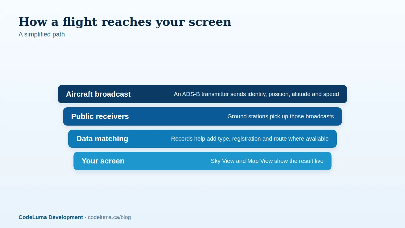
Many aircraft carry a transponder that broadcasts, using a system called ADS-B, their identity, position, altitude and speed. Receivers on the ground pick up these public broadcasts, and a tracker turns them into moving symbols on a screen. You do not need your own receiver or an API key to use SmartMarty Sky for normal use.
Not every aircraft broadcasts, and not every broadcast is received everywhere. Coverage, aircraft details and routes depend on available public broadcasts and verified records, so a missing detail does not mean anything is wrong.
The everyday curiosity payoff
The simplest reason to carry a tracker is that it answers a question you already have. Which flight just crossed the evening sky? Why is that plane so low and slow? Where is it heading? A quick look replaces a shrug with a name, a type and a direction.
It also makes the sky feel more like a place. Once you notice the same morning arrival every day, the sky above your home stops being background and becomes a schedule you can read.
Travel: following flights you care about
If someone you know is flying to you, a tracker lets you follow along by searching worldwide by callsign, registration or ICAO identity. You can see whether the aircraft has left, roughly where it is and how the flight is progressing. It is also handy for a relaxed pick-up, since you can see the aircraft approaching before you set out.
Keep the expectations honest. This is an information tool, not an official source, so airline and airport notices remain the place for timings and gate details. For tracking a flight you know about with the consent of the people involved, it is a pleasant extra layer.
Hobby uses: spotting, photos and logging
For plane spotters, live tracking removes a lot of guesswork. You can see what is inbound, identify a type before it appears over the treeline, and match a registration to what you photograph. SmartMarty Sky lets you save aircraft you want to watch again, set alerts, and take photos and silent video captures, all under your control.
A tracker is also a good learning aid. Comparing what you see in the sky with what the screen says teaches you to recognise engine layouts, wing shapes and tail designs faster than a reference book alone.
Choosing between Sky View and Map View
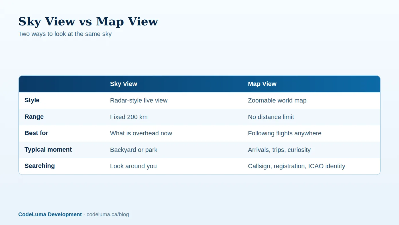
Sky View is a radar-style live view of aircraft within a fixed 200 kilometres. Use it when your question is "what is over me right now?" Map View is a zoomable world map with no distance limit, and it suits questions about flights elsewhere, such as following a long-haul flight or watching a distant airport.
The two work well together. Start with Sky View to identify what you can see, then jump to Map View to see where that flight came from and where it is going.
A simple first session
- Install it. Use the install page for Android, the iPhone and iPad web app, Windows, Linux or a browser.
- Pick a spot. Choose a public place with an open view of the sky.
- Open Sky View. Aim your phone at an aircraft and match it to the symbol on screen.
- Tap for details. Note the callsign, type and altitude, and save anything you want to revisit.
- Switch to Map View. Zoom out to see where the flight is heading.
New accounts can use 100% free access, so starting the free account is a low-effort way to test all this on a real evening. Public information can be read without a paid membership, and airport and aircraft pages are public.
Use airport pages to plan your spotting
Airports are where live tracking gets most interesting. Before heading out, browse the airport directory to find an airport near you and read its public page. Watching arrivals and departures on a map first tells you which direction planes tend to approach from, so you know where to look.
Runway direction can change with the wind, so what you see on one day may differ the next. Local weather in the app is a useful clue for that.

Quick checklist before you head out
- Charge your phone, and bring a power bank for a long session.
- Check the local weather and cloud cover.
- Choose a public spot that is clearly allowed for spectators.
- Have Map View ready for following flights beyond 200 km.
- Save a few aircraft or set alerts for flights you want to catch.
- Bring a notebook or use captures to log what you see.
Common mistakes to avoid
- Treating the screen as gospel. Positions are shown as broadcast and received, so small gaps and delays are normal.
- Expecting every aircraft. Some aircraft do not broadcast, so an aircraft you can hear but not see on screen is not a bug.
- Confusing callsign and registration. The callsign identifies a flight, often an airline code plus a number, while the registration identifies the specific aircraft. The same aircraft can fly under different callsigns on different days.
- Staying only in Sky View. The 200 kilometre limit is fixed, so use Map View for anything beyond it.
- Standing in the wrong place. Never trespass or block access for the sake of a better view.
Privacy, respect and limits
Good spotting is polite spotting. Stay in public places, follow airport rules and local signs, and keep photos and video to what is appropriate. Live tracking is about the flights, not about the people on them, and it is never a reason to guess at who is aboard a private aircraft or where they are going. You can read how the service handles data on the privacy page.
It is also important to be clear about what this is. SmartMarty Sky is an information and enthusiast tool. It is not an aviation safety, navigation or air-traffic tool, and it should never be used as one.
Is it right for your routine?
If you glance at planes and wonder, meet arriving relatives, or photograph aircraft on weekends, a live tracker earns its place on your home screen. If you rarely look up, the free account still makes a fair test. Try it on a walk, at the airport pick-up lot or in your own garden, and see whether the sky becomes more interesting.
Wrap-up
Live aircraft tracking is worth having because it makes a hidden layer of activity visible. Sky View answers what is overhead now, Map View follows flights anywhere, and both rest on public broadcasts, so results depend on what is available. Use it with curiosity and respect, keep it as a hobby tool rather than a safety one, and enjoy knowing what is flying overhead.
See what is flying overhead
If this made you curious about the planes above your own street, the 100% free access is an easy way to find out. Point your phone at the sky, open Sky View, and see how many of the overhead questions in this article you can answer in one evening.
- Create your free account - SmartMarty Sky is 100% free, with no ads and no credit card.
- Install SmartMarty Sky - Android, iPhone and iPad web app, Windows, Linux and browser options.
- Airport directory - medium and large airports worldwide, browsable by country.
- Privacy - how SmartMarty Sky handles data.
Look up and know. SmartMarty Sky shows live nearby aircraft on a radar-style Sky View and a worldwide map. Every feature is 100% free — no ads and no credit card. It is an enthusiast information tool, not a navigation or safety system.