
Open SmartMarty Sky for the first time and you'll notice two very different ways to look at the same live aircraft data: a radar-style Sky View and a worldwide Map View. They're not competing features, they're built for different questions. One answers "what's that overhead right now?" and the other answers "where is that flight, anywhere on the planet?" Knowing which one to reach for saves time and makes the app far more useful, whether you're standing in your backyard or tracking a friend's route across an ocean.
What Sky View Actually Shows
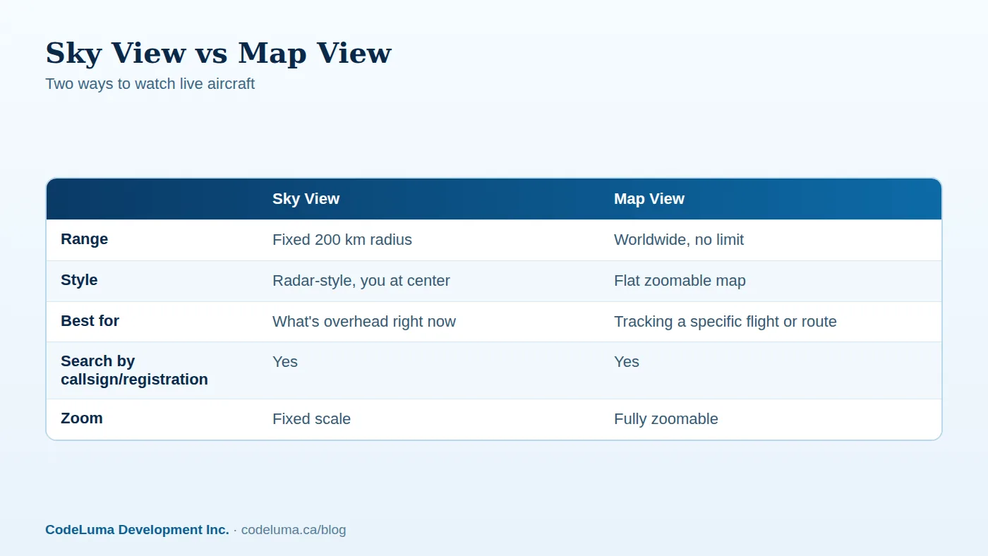
Sky View is the radar-style display: you are the center of the screen, and aircraft appear around you within a fixed 200 kilometre radius. It's designed to feel like a classic radar scope, with aircraft moving in relation to your position as new public ADS-B broadcasts come in. If you've ever wondered what that distant engine noise belongs to, or you want to watch a stream of inbound traffic lining up for a nearby runway, Sky View is built exactly for that moment.
Because the radius is fixed, Sky View isn't meant for exploring distant regions. It's a "right here, right now" tool, and that focus is its biggest strength. For a deeper look at how those broadcasts actually work, our explainer on ADS-B covers the basics.

What Map View Actually Shows
Map View flips the perspective. Instead of centering on you, it gives you a zoomable world map with no distance limit. You can pan from a local airport out to an entire continent, follow a route stretching over an ocean, or zoom into a cluster of regional traffic near a busy hub. Map View is where you go when the question isn't "what's near me" but "where is this particular aircraft, and where has it been headed."
Both views pull from the same public ADS-B data and both support worldwide search by callsign, registration or ICAO identity, so you're never locked out of a lookup just because you picked the "wrong" view first.
Sky View vs Map View: Side by Side
At a glance, the difference comes down to range versus reach. Sky View trades distance for a radar-like sense of immediacy, aircraft orbiting around your location. Map View trades that centered feel for unlimited geographic reach and the ability to zoom in or out as needed.
- Sky View: fixed 200 km radius, radar-style layout, centered on you.
- Map View: zoomable, worldwide, centered on whatever you choose to look at.
When to Use Sky View
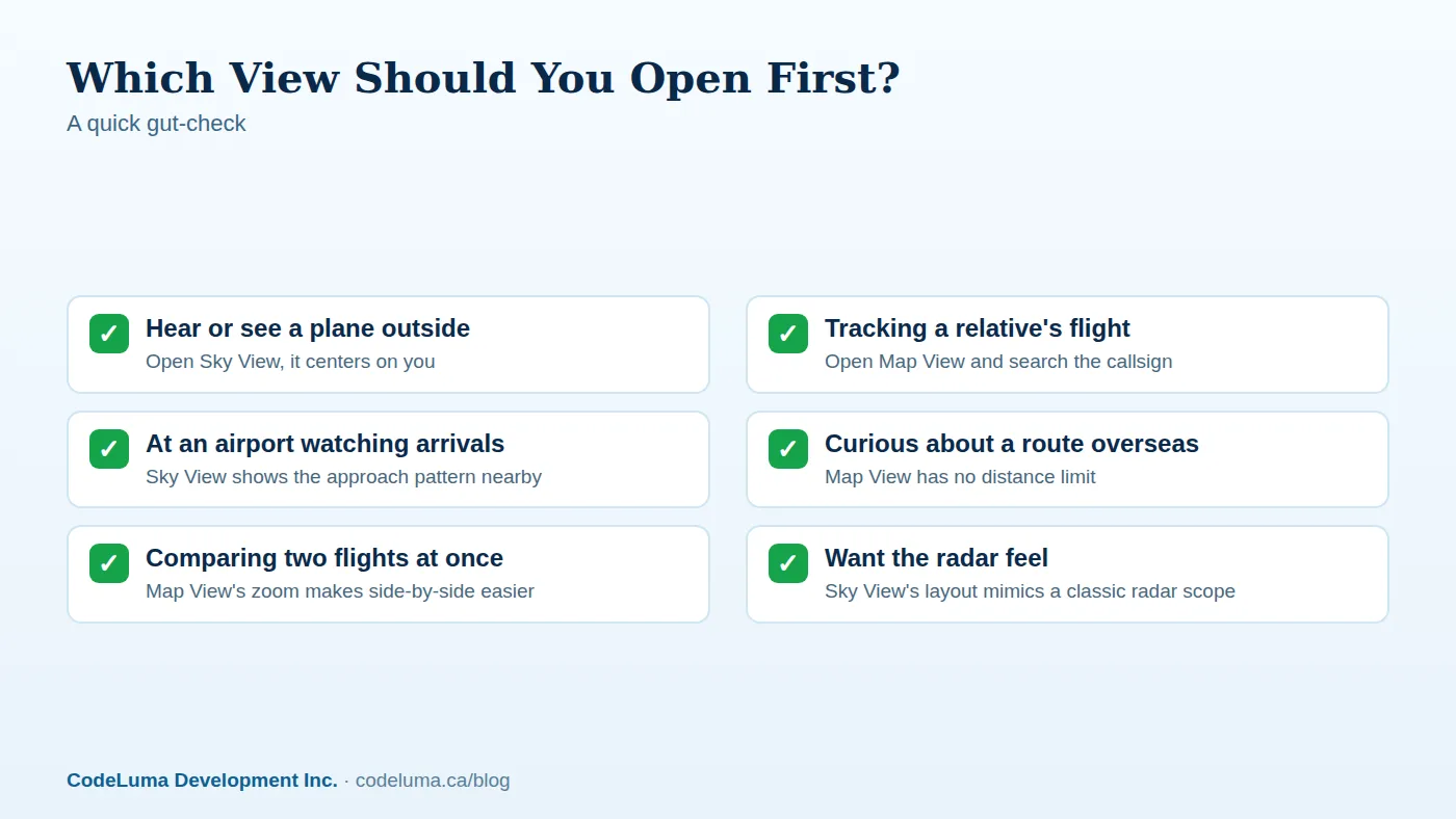
Reach for Sky View when the question is physical and immediate. A jet rumbles overhead and you want to know what it is. You're watching a holding pattern form near an airport before a shift change. You're set up at a good spotting location and want a live radar-style read of what's inbound within range. Sky View's fixed radius keeps the display simple and fast to read, which matters when you're trying to match a blip to a plane you can actually see or hear.
Good moments for Sky View
- Plane spotting sessions near an airport or under a flight path
- Identifying unusual overhead noise
- Watching local arrival and departure flow build up
When to Use Map View
Map View earns its keep whenever distance matters. Following a relative's long-haul flight, checking whether an aircraft has left the gate on the other side of the world, or just exploring which routes are active over a region you're curious about, these are all Map View jobs. Because it has no distance limit, it's also the better choice for comparing routes or watching an aircraft's progress across an entire flight, not just the stretch that happens to pass near you.
How to Switch Between Them
Switching views in SmartMarty Sky is deliberately simple, since the whole point is to let curiosity move quickly:
- Open the app and pick Sky View or Map View from the main navigation.
- In Sky View, nothing to configure, it centers on your location automatically within the 200 km radius.
- In Map View, pan or zoom to the region you want, or search by callsign, registration or ICAO identity to jump straight to an aircraft.
- Switch views at any time, your search or saved aircraft carry over.
Using Search the Same Way in Both Views
One underrated detail: search works the same whether you're in Sky View or Map View. Type in a callsign, registration or ICAO identity and the app will locate that aircraft if it's currently broadcasting public ADS-B data. This means you don't have to guess which view has the lookup tool, both do, so you can start in whichever view matches your immediate question and search from there.

Common Mistakes to Avoid
- Expecting Sky View to reach far away traffic. It's fixed at 200 km by design, that's a feature for clarity, not a bug.
- Forgetting Map View has no zoom floor or ceiling issue. If a route looks cramped, zoom in; if you've lost context, zoom out.
- Assuming every aircraft will appear. Coverage depends on available public broadcasts, so some aircraft or stretches of a route may not show up, and that's expected, not an error.
- Treating either view as a safety or navigation tool. SmartMarty Sky is built for enthusiasts and the curious, not for flight planning or air traffic decisions.
Using Both Together
The two views complement each other more than they compete. A common pattern: spot something interesting in Sky View, note the callsign or registration, then jump to Map View to see the bigger picture of where that flight came from or is headed. Or start in Map View tracking a route, then switch to Sky View once that aircraft gets close enough to be part of your local 200 km radius. Saved aircraft and alerts work across both, so you don't lose track of something you're following just because you changed views.
A Quick Checklist for Choosing
If you're ever unsure which view to open first, ask yourself whether the question is about "here" or "there." Here means Sky View. There, especially far there, means Map View. Either way, both views draw from the same airport directory and public aircraft data, so nothing is hidden behind one view versus the other.
Wrap-Up
Sky View and Map View aren't rivals, they're two lenses on the same live sky. Sky View keeps things radar-simple and local, perfect for the moment a plane passes overhead. Map View opens up the whole planet, ideal for following routes and flights wherever they go. Together, they turn public ADS-B broadcasts into something genuinely useful for plane spotters, travellers and anyone who's ever looked up and wondered. Try installing SmartMarty Sky on your device, or start the one-time 60-minute trial and flip between both views to see which one answers your next question.
See what is flying overhead
Curious which view fits the moment, the plane rumbling overhead or the flight your friend is boarding across the ocean? Start the free trial and flip between Sky View and Map View yourself, no receiver or account setup beyond the basics required.
- Start the free trial - a one-time 60-minute live-access trial for new accounts.
- Install SmartMarty Sky - Android, iPhone and iPad web app, Windows, Linux and browser options.
- Airport directory - medium and large airports worldwide, browsable by country.
- Blog - more aviation stories and guides.
Look up and know. SmartMarty Sky shows live nearby aircraft on a radar-style Sky View and a worldwide map. New accounts can use a one-time 60-minute live-access trial. It is an enthusiast information tool, not a navigation or safety system.