
If you've ever watched a dot glide smoothly across a live aircraft map and wondered how anyone on the ground knows exactly where that plane is, the answer is simpler than most people expect. It isn't secret military tracking or satellite spy tech. It's a public broadcast that the aircraft itself is sending out, on purpose, to anyone listening. That broadcast is called ADS-B, and understanding it is the key to understanding everything SmartMarty Sky shows you.
ADS-B Is Short for Something Very Literal
ADS-B stands for Automatic Dependent Surveillance-Broadcast. Each word describes exactly what it does. It's automatic, meaning the aircraft sends it without a pilot pressing a button. It's dependent, meaning it relies on the aircraft's own navigation data rather than an outside radar beam measuring it. And it's a broadcast, meaning the signal goes out openly, to anyone with the right kind of receiver, not to a single recipient. There's no password, no encryption, and no permission needed to listen.

Where the Position Data Comes From
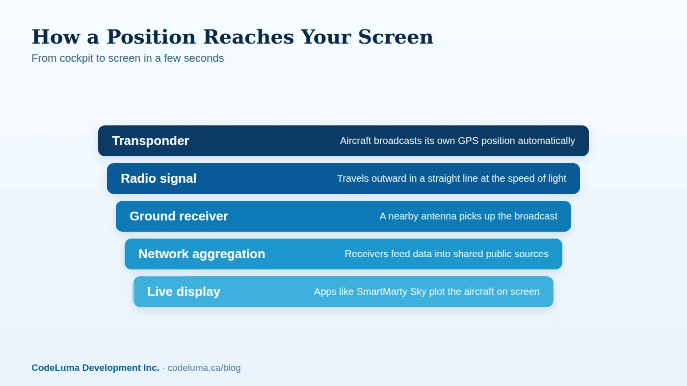
Modern aircraft already know where they are with remarkable precision, thanks to GPS and other onboard navigation systems. ADS-B takes that existing data, which includes latitude, longitude, altitude, ground speed, and heading, and packages it into a small digital message. The aircraft's transponder then transmits that message outward continuously while the aircraft is powered up and in many cases while taxiing on the ground.
A Signal Sent Into the Open Air
The broadcast travels on a public radio frequency, and it isn't aimed at any particular listener. It behaves a bit like a lighthouse beam: the aircraft sends it out in all directions, and whatever is in range and tuned to the right frequency can pick it up. This is a deliberate design choice. ADS-B was built as part of a global shift toward satellite-based navigation, replacing some of the guesswork of older ground radar with direct, aircraft-reported positions.
Ground Receivers: The Ears on the Ground
For that broadcast to become useful, something has to catch it. That's the job of ground receivers, small antennas, often no larger than a car radio aerial, mounted on rooftops, towers, or even simple poles in backyards. These receivers don't ask the aircraft for anything. They just listen continuously, and whenever a signal arrives, they decode it into readable data: identity, position, altitude, and movement. A single receiver only hears aircraft within its own radio horizon, but there are thousands of them around the world, run by aviation enthusiasts, researchers, and organizations, each contributing a small patch of sky.
From One Receiver to a Worldwide Picture
No single receiver sees the whole planet, but when many receivers share what they hear, their coverage overlaps and fills in. That shared pool of data is what lets an app show you traffic far beyond what any one antenna could pick up alone. This is the step where raw radio signals become the smooth, continuously updating picture you actually see on a screen. If you want the deeper, byte-level version of what's packed into each message, we've broken that down separately.
What a Typical Broadcast Actually Contains
Each ADS-B message is small but dense. It typically carries the aircraft's unique ICAO identifier, its callsign, GPS position, barometric altitude, ground speed, heading, and whether it's climbing, descending, or level. Put dozens of these messages together over a few seconds, and you get the smooth animated movement you see in a live map rather than a jumpy, occasional ping.
Why This Replaced So Much Guesswork
Traditional ground radar works by bouncing a pulse off an aircraft and measuring how long it takes to return, which gives a reasonably good but imprecise fix on position, and it needs an expensive rotating radar installation to do it. ADS-B flips that around: the aircraft already knows its own position precisely via GPS and simply tells everyone. That's why ADS-B can be received with comparatively modest, inexpensive equipment, and why hobbyist tracking became possible at all. For the fuller history of how we got from radar scopes to broadcasts like this, see our earlier piece on that evolution.
Why Coverage Isn't Perfectly Even
Because ADS-B reception depends on line of sight between the aircraft and a receiver, geography matters. Mountains, hills, and the curve of the earth itself can block a signal, which is why low-flying aircraft over remote terrain or far out over open ocean are harder to pick up than a jetliner cruising at altitude over a city with several receivers nearby. This isn't a flaw in any particular app, it's simply a property of radio: more receivers in an area means better coverage, and sparsely covered regions will always have gaps. SmartMarty Sky's coverage, aircraft details, and routes depend entirely on what public broadcasts and verified records are actually available at any given moment.

Seeing It for Yourself
You don't need to build or own a receiver to see any of this in action. SmartMarty Sky already does the listening for you through its network, so you can just open the app and watch. A few practical ways to start:
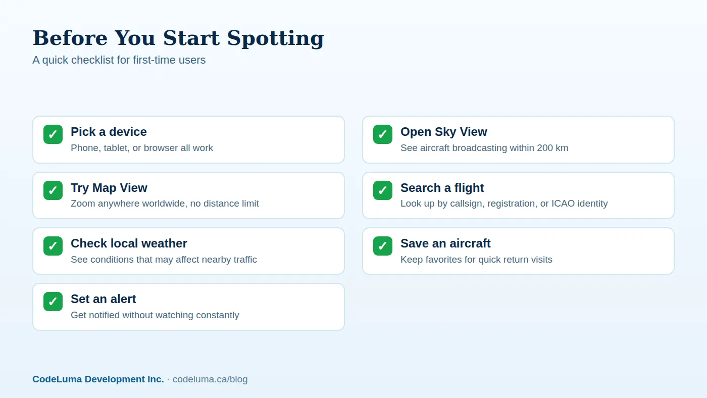
- Open Sky View to get a radar-style look at everything broadcasting within 200 kilometres of your location right now.
- Switch to Map View to follow traffic anywhere in the world, with no distance limit, by panning and zooming.
- Search by callsign, registration, or ICAO identifier if you already know which aircraft you're curious about.
- Tap an aircraft to see what public data is currently available for it, keeping in mind that details and routes aren't guaranteed for every flight.
You can install SmartMarty Sky on Android, as a web app on iPhone or iPad, or use it in a browser on Windows and Linux, and public information like airport pages and aircraft pages doesn't require a paid membership to read. If you want unrestricted live access to try everything first, new accounts get a one-time 60-minute live-access trial.
Common Mistakes to Avoid
- Expecting every aircraft to show up. Military, some general aviation, and certain other aircraft may not broadcast ADS-B data publicly, or may not be in range of a receiver.
- Treating the app as a safety or navigation tool. It's built for enthusiasts and the curious, not for flying, air traffic control, or any operational decision.
- Assuming a gap means something is wrong. A missing dot over open water or rough terrain is usually just a receiver coverage gap, not an error.
- Confusing registration with ownership details. Public broadcast data identifies the aircraft, not necessarily anything about who's aboard it.
A Quick Checklist Before You Start Watching
- Know roughly where you are, since Sky View centers on your location out to 200 kilometres.
- Have a callsign, registration, or ICAO code ready if you're hunting a specific aircraft.
- Check the local weather in the app if you're planning to spot in person.
- Remember that SmartMarty Sky needs no personal receiver or API key for normal use.
- If you want to go further, the optional receiver guide covers advanced setups for enthusiasts who'd like to run their own antenna.
The Bigger Picture
What makes ADS-B remarkable isn't the complexity of the technology, it's how openly it's shared. A system built for coordinating global air traffic also happens to let anyone with curiosity and a phone watch the sky come alive. That's the whole premise behind SmartMarty Sky: taking public broadcasts that are already out there and turning them into something clear, visual, and genuinely enjoyable to explore, whether you're spotting from a park bench near an airport fence line or just wondering what that distant contrail belongs to.
Wrapping Up
Every dot you see moving across a SmartMarty Sky map traces back to the same simple chain: an aircraft calculates its own position, broadcasts it openly, a ground receiver somewhere catches it, and a network stitches it all together. No secrets, no special access, just physics and a bit of shared infrastructure. Once you know that chain, the live sky stops feeling mysterious and starts feeling like something you can actually read.
See what is flying overhead
Curious what's actually flying overhead right now? Open SmartMarty Sky, point your phone at the sky with Sky View, or browse the world in Map View, no personal receiver required. New accounts get a one-time 60-minute live-access trial to see the broadcasts described in this article turn into real dots on your screen.
- Install SmartMarty Sky - Android, iPhone and iPad web app, Windows, Linux and browser options.
- Start the free trial - a one-time 60-minute live-access trial for new accounts.
- Optional receiver guide - advanced receiver setup for enthusiasts.
- Airport directory - medium and large airports worldwide, browsable by country.
Look up and know. SmartMarty Sky shows live nearby aircraft on a radar-style Sky View and a worldwide map. New accounts can use a one-time 60-minute live-access trial. It is an enthusiast information tool, not a navigation or safety system.