
Open SmartMarty Sky and you'll notice two very different ways to watch the same aircraft: a radar-style Sky View that circles around you, and a Map View that stretches across the whole planet. Both pull from the same public ADS-B broadcasts, but they answer different questions. Knowing which one to reach for saves time and makes the hobby more satisfying, whether you're standing under a flight path or researching a route from your couch.
What Sky View Actually Shows You
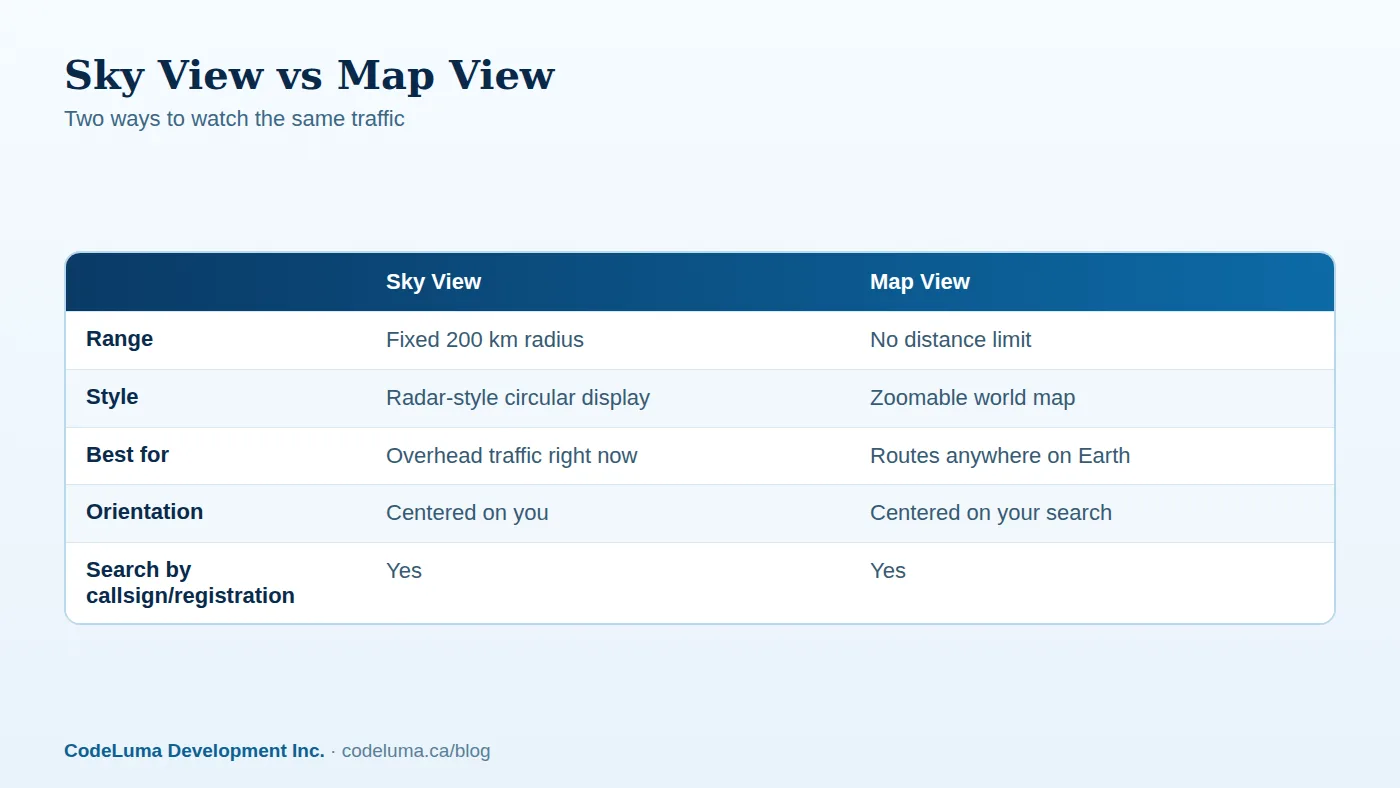
Sky View is built for the moment you're standing outside, phone in hand, trying to match a sound overhead to an actual aircraft. It's a radar-style display fixed to a 200 kilometre radius around your location, so everything you see is genuinely nearby. The layout mimics a traditional radar scope: your position at the center, aircraft arranged around you by direction and distance, updating as they move.
This is the view most people open first, because it mirrors the instinct of looking up. If a jet rumbles overhead, Sky View is the fastest way to confirm what it is without guessing.

What Map View Actually Shows You
Map View drops the fixed radius entirely. It's a standard zoomable world map with no distance limit, so you can pan from your backyard to another continent and watch different traffic along the way. Combined with search by callsign, registration or ICAO identity, Map View turns into a tool for following a specific aircraft's route rather than just what's nearby.
Because it isn't tied to your location, Map View is also the better choice for exploring unfamiliar airspace, tracing a route between two cities, or simply browsing what's airborne somewhere else in the world right now.
When Sky View Is the Better Choice
Reach for Sky View when:
- You're physically outside and want to match a plane you can see or hear to its identity.
- You're at a known spotting location, perhaps one you found using tips for picking a good spotting spot, and want everything local in one glance.
- You want the radar-style feel of classic air traffic displays, centered on where you're standing.
When Map View Is the Better Choice
Switch to Map View when:
- The aircraft you care about has already flown beyond the 200 km Sky View range.
- You're searching for a specific flight by callsign or registration and want to see its full path, not just the local segment.
- You're researching an airport you've never visited, checking what typically flies in and out before a trip.
- You want the big picture: animated live maps showing traffic across a region or the globe.
Using Both Views Together
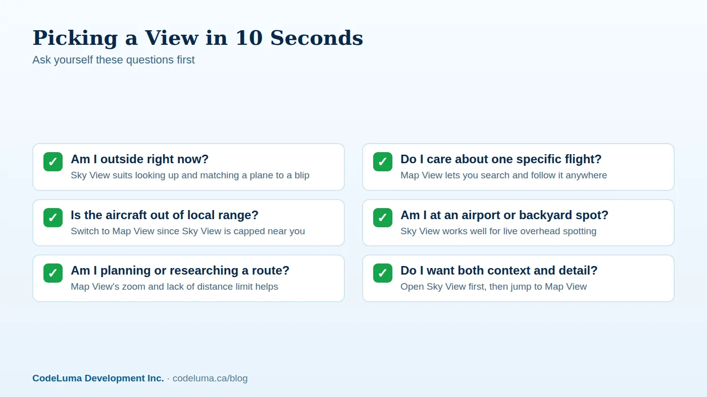
The two views aren't competitors; they're stages. A common pattern is to open Sky View first to see what's overhead, spot an interesting aircraft, then switch to Map View to follow where it came from or where it's headed next. This pairing is especially useful if you've ever wondered why a delay traces back to weather somewhere else — Map View lets you see the broader picture that Sky View alone can't show.
Aircraft pages in SmartMarty Sky are public, so once you've identified something interesting in either view, you can tap through for more detail without needing an account.
How to Switch Between Views
- Open SmartMarty Sky on your phone, tablet or browser.
- Start in Sky View if you're outside, or Map View if you already know what you're looking for.
- Use the search bar to look up a callsign, registration or ICAO identity at any point.
- Tap an aircraft icon to open its page for route and identity details, where available.
- Switch views from the main navigation whenever your question changes from "what's near me" to "where is this going."

Common Mistakes to Avoid
A few habits trip up new users:
- Expecting Sky View to show distant traffic. Its 200 km range is fixed by design; anything farther simply won't appear there.
- Forgetting Map View has no distance limit. If a search comes up empty in Sky View, that doesn't mean the aircraft isn't flying — try Map View before assuming there's no data.
- Treating either view as a navigation tool. SmartMarty Sky is an information and enthusiast tool built from public broadcasts, not an aviation safety or air-traffic system.
- Assuming every aircraft is visible. Coverage depends on available public broadcasts, and some aircraft or details may be missing or incomplete.
A Quick Checklist for Choosing
- Standing outside, looking up? Start with Sky View.
- Chasing a specific flight across distance? Use Map View.
- Want local plus global in one session? Use Sky View, then jump to Map View.
- Researching before a trip or visit to an airport? Map View is usually faster.
Why This Matters for Plane Spotters and Travellers
The value of having two views isn't just convenience, it's matching the tool to the question. A spotter standing at a fence line wants immediate, local context; a traveller curious about an inbound flight wants the full journey. SmartMarty Sky separates those needs cleanly instead of forcing one cluttered display to do both jobs. That's part of why live aircraft tracking has become such an easy habit to pick up, as covered in why live aircraft tracking is worth having in your pocket — the right view, at the right moment, turns a glance at the sky into something you actually understand.
The Takeaway
Sky View and Map View aren't rival features, they're two lenses on the same public data. Use Sky View when the sky above you is the story; use Map View when the story stretches further than you can see. Learning to switch between them is the fastest way to get more out of SmartMarty Sky, whether you're spotting from a backyard or tracing a route halfway across the world.
No personal receiver or API key is needed to try either view, and public aircraft and airport pages are open to browse any time.
See what is flying overhead
Curious which view fits your plane-spotting style? Open SmartMarty Sky and flip between Sky View and Map View in seconds, no personal receiver required. New accounts get a one-time 60-minute live-access trial to test both right away.
- Install SmartMarty Sky - Android, iPhone and iPad web app, Windows, Linux and browser options.
- Start the free trial - a one-time 60-minute live-access trial for new accounts.
- Airport directory - medium and large airports worldwide, browsable by country.
- Blog - more aviation stories and guides.
Look up and know. SmartMarty Sky shows live nearby aircraft on a radar-style Sky View and a worldwide map. New accounts can use a one-time 60-minute live-access trial. It is an enthusiast information tool, not a navigation or safety system.