
Watch a plane cross the sky in SmartMarty Sky and it feels almost telepathic, as though the app simply knows where that aircraft is. It isn't magic. The aircraft is telling everyone, openly, several times a second. That broadcast is called ADS-B, and once you know what's actually packed inside it, live tracking stops feeling mysterious and starts feeling obvious.
What ADS-B Stands For
ADS-B is short for Automatic Dependent Surveillance–Broadcast, and each word earns its place. Automatic means the aircraft sends it without a pilot pressing a button each time. Dependent means the position comes from the aircraft's own navigation equipment, usually GPS, rather than being measured by someone on the ground. Surveillance reflects its purpose of tracking traffic. Broadcast is the key word for curious observers: the message isn't addressed to one controller or one airline. It's sent openly, for anyone within range to pick up.

The Data Packed Into Every Broadcast
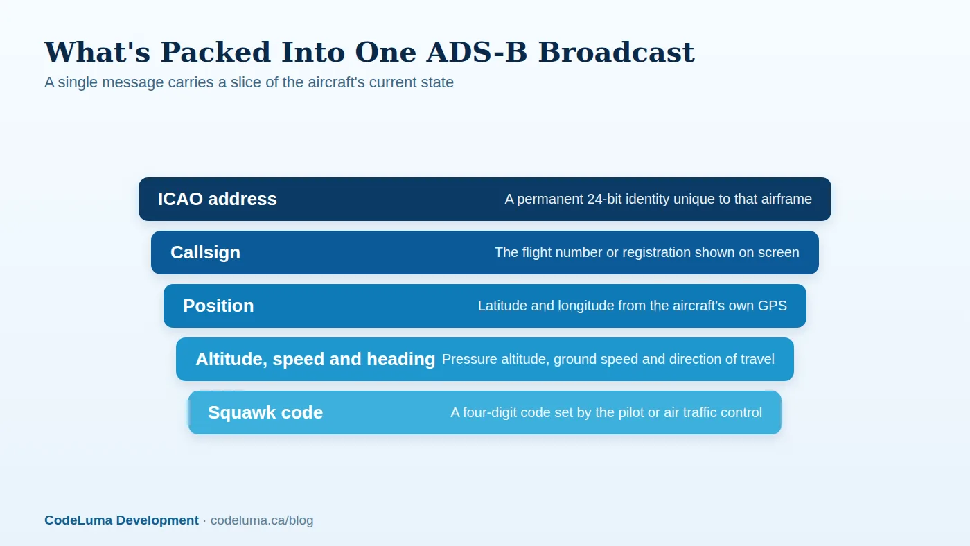
A modern ADS-B Out transmitter sends out several message types, and together they build the full picture you see on a tracking map. The aircraft's ICAO 24-bit address works like a permanent fingerprint, unique to that specific airframe for its entire life. Separate messages carry the callsign or flight identifier, GPS-derived latitude and longitude, altitude, ground speed, heading, vertical rate, and the squawk code assigned by the pilot or a controller. None of this is encrypted or hidden. It's designed to be read by anyone's receiver, which is exactly why apps like SmartMarty Sky can turn it into a live Map View or Sky View without needing a direct feed from any airline or air traffic authority.
Why Transmissions Are Public by Design
ADS-B was built as an open safety broadcast, not a private data feed. Aviation authorities around the world chose to make this information openly receivable on purpose, because the entire point is for any suitably equipped aircraft or ground station nearby to pick it up and build a shared picture of traffic. That same openness is what lets enthusiasts, researchers, and apps listen in too. Nobody needs special clearance to receive a public broadcast that was designed to be heard.
From Ground Radar to Self-Reported Position
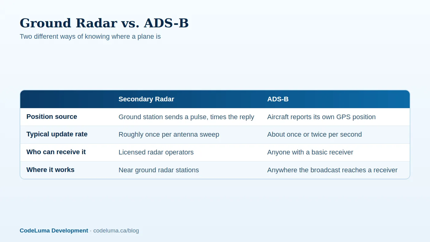
Traditional secondary surveillance radar works by interrogation: a ground station sends a pulse, the aircraft's transponder replies, and the station calculates position from the direction and timing of that reply. It's effective, but it's also limited to areas with radar coverage and depends on infrastructure that's expensive to build and maintain. ADS-B flips the process. The aircraft already knows its own position from GPS, so instead of waiting to be asked, it simply announces it. Over the past couple of decades, aviation authorities in many countries have required ADS-B Out equipage in controlled airspace, extending this kind of visibility well beyond what ground radar alone could offer.
How Often a Plane "Speaks"
Airborne ADS-B position messages go out roughly once or twice every second, with other message types like identification sent a bit less frequently. That steady drumbeat is why a well-tracked flight appears to glide smoothly across a live map instead of jumping between distant points. It also means that within moments of taking off, an aircraft is already broadcasting its climb, heading and speed to anything listening.
What ADS-B Doesn't Tell You
It's worth being clear about the limits too. A broadcast carries identity and flight state, not engine health, cabin conditions, or crew intentions. Some aircraft, particularly certain older, smaller, military or government types, may not transmit ADS-B at all, or may do so inconsistently. Coverage and detail always depend on what's actually being broadcast and received nearby, so gaps in a track usually mean missing data rather than anything unusual. This is also a good moment for a reminder: ADS-B tracking is an information and enthusiast tool. It is not an aviation safety or navigation tool, and it should never be treated as one.
See It for Yourself
The fastest way to understand ADS-B is to watch it work. A few simple steps turn the theory into something you can see on your own screen:
- Install SmartMarty Sky on your phone, tablet or browser.
- Open Map View for a worldwide look, or step outside and use Sky View for a radar-style picture of aircraft within 200 kilometres.
- Search a flight by callsign, registration or ICAO identity to find a specific aircraft.
- Watch its position, altitude and speed update live as new broadcasts arrive.
- If you want to go further, read the optional receiver guide to learn how enthusiasts pick up raw ADS-B signals themselves.

Common Mistakes When Reading Public Flight Data
A few habits trip up newcomers to live tracking. It helps to know them before you form the wrong impression:
- Assuming a missing or vanished track means something suspicious, when it's usually just a gap in public broadcast coverage.
- Mixing up callsign and registration, which are different identifiers shown together on most aircraft pages.
- Treating displayed altitude or speed as a precise, instantaneous reading rather than the aircraft's last broadcast value.
- Expecting every aircraft worldwide to appear, when coverage depends on available public broadcasts and verified records.
- Using a tracking app for navigation or safety decisions, which it was never designed for.
Why This Openness Matters
Once you realize an ADS-B broadcast is simply public information the aircraft is choosing to share, the whole hobby makes more sense. You're not intercepting anything private. You're reading a signal that was built to be read, the same way a lighthouse beam is built to be seen. That's what makes plane spotting accessible to anyone with curiosity and a phone, and it's the same openness that lets travellers check on an inbound flight or an aviation fan follow a rare aircraft across a continent.
A Quick Checklist Before You Dive In
- You don't need a personal receiver or API key for normal use.
- Sky View shows live traffic within a fixed 200 kilometres, radar-style.
- Map View is zoomable with no distance limit, worldwide.
- Callsign, registration and ICAO identity are all valid ways to search.
- Public aircraft and airport pages can be read without a paid membership.
- Coverage and details depend on available public broadcasts, so gaps can happen.
The Sky Is Already Talking
ADS-B strips away the mystery of live tracking the moment you understand it: it's a public broadcast, sent automatically, carrying identity and flight state for anyone to hear. Everything a tracking app shows you starts with that signal. Start your free account of SmartMarty Sky and watch that public data turn into a live, readable picture of the sky above you.
See what is flying overhead
Curious what a plane overhead is actually telling the sky right now? Install SmartMarty Sky and open Map View or Sky View to watch those broadcasts turn into a live, readable track in seconds. New accounts get 100% free access, no personal receiver required.
- Install SmartMarty Sky - Android, iPhone and iPad web app, Windows, Linux and browser options.
- Create your free account - SmartMarty Sky is 100% free, with no ads and no credit card.
- Optional receiver guide - advanced receiver setup for enthusiasts.
- Blog - more aviation stories and guides.
Look up and know. SmartMarty Sky shows live nearby aircraft on a radar-style Sky View and a worldwide map. Every feature is 100% free — no ads and no credit card. It is an enthusiast information tool, not a navigation or safety system.